Our complex Maria’s Filoxenia Suites is at the centre, among the internationally known archaelogical sites and popular touristic resorts of Argolis and the islands of Argosaronikos Strand.
ARCHAELOGICAL SITES
• Ancient Corinth – 60 km of distance
Almost an hour from the property is ancient Corinth, the city that was inhabited since the Neolithic period (6500-3250 BC) and was known from Mycenaean times. For this reason, it is referred to in Homer as “aphneios = rich”, due to its highly fertile land, making it one of the most important cities of ancient Greece. Its heyday begins from the 8th BC, a century of significant political, military, commercial and cultural activity. The creation of colonies in the west of the Mediterranean, with the most important ones in Sicily, helped Corinth to emerge as one of the most important trading powers of the time. Their most definitive colonial move was the founding of the city of Syracuse, which developed into the most important city in Sicily.
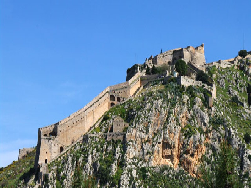
Acrocorinth is a steep rock 575 meters high, that dominates near the plain of Corinth. On its northern foothills was built Ancient Corinth. Due to its morphology, it was used since ancient times as a watchtower that emerged as a castle – fortress (Citadel), from which any raid from Central Greece or from the sea was supervised.
The tyrant Periander and his father Cypselus first fortified Acrocorinth in the 7th-6th centuries BC and slowly developed into a Citadel. The Macedonians, in the 4th century BC, repaired and strengthened the walls. In 146 BC, the Roman General Lucius Mommius Achaean destroyed Corinth and its Citadel when he captured Greece. Julius Caesar repaired the castle in 44 BC. In 52 AD, Corinth receives the visit of the Apostle Paul during his second Apostolic tour in which, among other things, he writes the first and Second Epistle to the Thessalonians. The Apostle Paul also visited Corinth on his third tour during which he wrote The Epistle to the Romans.
The most important monument of the exterior is of course the Great archaic Temple of Apollo, more than 2,500 years old, where it was built in 530 BC, in the Doric style.
The magnificent view from Acrocorinth is truly breathtaking and has literally “dish” half the Peloponnese. It is the largest castle in Greece and one of the largest in Europe. The castle has a perimeter of walls about 3 km and is worth walking all over. You will need more than two hours for a simple guided tour and leisurely walk. Loutraki, Isthmia and Corinth are very close and will offer you dozens of choices in taverns or restaurants. In case you have small children in the company, the playground located there will delight them.
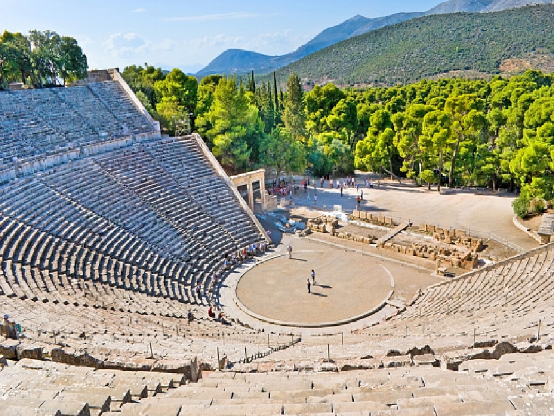
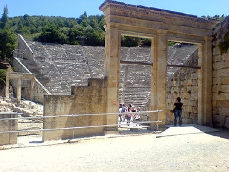
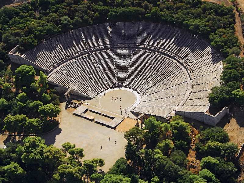
• Ancient Theatre of Epidaurus – 30 km of distance
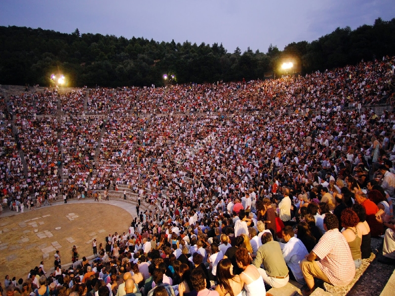
The Ancient Theatre of Epidaurus is located in Argolida, at the archaeological site of Asklepieion, half an hour drive from our accommodation. It is located at the southeastern end of the sanctuary at the Asklepieion of Epidaurus, which was dedicated to the healing God of antiquity, Asklepios. According to Pausanias, it was built in a ravine, in 340 BC, by the architect Polykleitos from Argos, where thanks to him, the theatre of Epidaurus is famous for its symmetry and beauty. The aesthetic harmony was due to the regularity and mathematical relevance of its individual sizes, where combined with its exquisite acoustics, it allowed the listeners of the upper stands to hear even the slightest sound from the orchestra. Therefore, the aesthetics and functionality of the theater had already been noted since antiquity, which is why it hosted musical competitions and performances of ancient drama. Intended therefore for the entertainment of the sick, it had a capacity of 13,000 spectators. Thus, it is divided into two parts: one of 21 rows of seats for the people and the lower, of 34 rows of seats, for the priests and rulers.
The theatre of the city of Epidaurus was discovered in 1970 and fully revealed in 1989 and has been included by UNESCO in the list of World Heritage Sites. Of all the ancient theatres, the Theatre of Epidaurus is the most beautiful and the best preserved. Its wonderful acoustics, as well as the very good condition in which it is preserved, contributed to the creation of the Epidaurus Festival, an institution that has started many years ago. During the months of July and August, the Theatre presents performances in the framework of the Greek Festival.
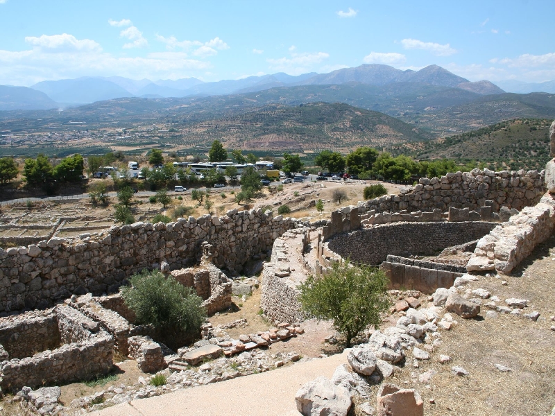
• Ancient site in Mycenae – 30 km of distance
The archaeological site of Mycenae, 20 minutes away from our accommodation, is protected by UNESCO and can be characterized as one of the most important historical monuments of Greek culture, gathering many tourists from every corner of the Earth. Mycenae is an ancient city of the prefecture of Argolis and Kingdom of the mythical Agamemnon, leader of the Achaeans during the Trojan War, which was the most important and richest palatial center of The Late Bronze Age (1350 BC. -1200 BC.) in Greece.
Speaking with pure historical data, we can say that Mycenaean was named the civilization that developed with the center of Mycenae, the so-called “Mycenaean” or “late helladic” period of ancient history. This period is divided into the early late helladic period (1600 – 1500 BC.), in the middle late helladic period (1500 – 1400 BC.) and in the later late helladic period (1400 – 1100 BC.), when successive disasters led to the final decline of the Mycenaean civilization.
However, the visitor of the archaeological site can see a plethora of remarkable monuments of unparalleled historical importance. Initially the huge cyclopean walls, whose way of construction is an inconceivable achievement for that time by the ancient Greeks. One hundred years later, The Lion Gate was built, representing two lions, as Guardians of the Acropolis and is a particularly remarkable monument. Outside the walls are the vaulted tombs of Clytemnestra and Aegisthus, while outside the main archaeological site you enter the most impressive vaulted tomb in the country, the treasure of Atreus or Tomb of King Agamemnon. Then, the Royal Palace, the temple, the North Gate and the underground tank, are equally important and pioneering achievements of the time, which testify to the genius of the ancient Greeks.
• Ancient Theatre of Argos – 20 km distance
The Argos Theatre was built in 320 BC and it is located in Argos of Argolida, about 20 minutes from the accommodation, on Larissa Hill. In front of the site is the Agora, the Roman Theatre and the Baths of Argos. It is one of the greatest archaeological achievements in Greece, as well as the top cultural monument of Argos. With a capacity of about 20,000 spectators, it is one of the largest ancient theatres in Greece. In the hollow, there are four stands, corresponding to the tribes of the Argos people. The orchestra had the “charonian scale”, where actors playing dead or chthonic deities appeared. In its long use, it hosted the musical and dramatic games of the Nemeans, as well as games in honor of the ancient goddess Hera. In the Roman, games were also established in honor of the emperor. On 15. 7. 1829, the 4th National Assembly of the New Greek state was held at the theatre.
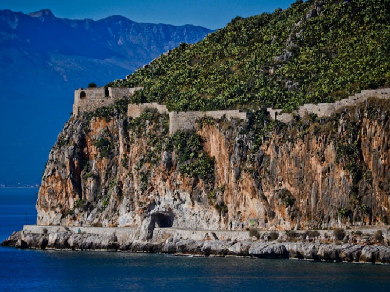
• Ancient Tiryns Acropole – 14 km of distance
In Argolis, about 8 km from Nafplio, is the Acropolis of ancient Tiryns, the once Center of the Mycenaean world. The Low Hill of Tiryns, has been inhabited uninterruptedly since the Neolithic era (about 5,000 BC) until late antiquity. During prehistoric times the area flourished mainly during the early and Late Bronze Age (2500-2000 BC). The mythical cycles of Bellerephontes, Perseus, and Hercules, are associated with the Acropolis of ancient Tiryns. The ancient Acropolis of Tiryns was founded by the homonymous hero Tiryns, son of Argos and grandson of Zeus, who according to mythology, built the impregnable walls with the help of the Cyclops. Ancient Tiryns was a naturally fortified position and controlled a large area of the plain, as well as important crossings to Argos, Mycenae, Nafplion and Epidaurus.
It consists of two main buildings and houses that extend to the southern part of the hill, the so-called Upper Acropolis. During the same period, the northern, lower part of the hill, the so-called lower Acropolis, was fortified for the first time and the Palace on the upper Acropolis was repaired. Inside the lower Acropolis a Megaron-shaped building functioned as a sanctuary of the Ancient Gods of Hera, Athena and Apollo.
The western bastion is also an outstanding achievement of Mycenaean architecture that has a very clear defensive character. Moreover, the cyclopean walls of the Acropolis surround the entire hill, and create a strong fortification enclosing an area of approximately 20,000 square meters.
Four different building periods have been observed in the Acropolis of ancient Tiryns, but only at the end of the 13th BC century, the walls and the Palace seem to take their final form
In 1828, Kapodistrias founded a building south of the Acropolis of ancient Tiryns for the operation of an agricultural school. In the same place today, the rural prisons of Nea Tiryns are housed. A few kilometers away, the visitor meets the vaulted tomb of Tiryns, the famous Mycenaean dam of Tiryns, and one of the oldest known Greek shrines, the ancient Heraion.
Today the Acropolis of ancient Tiryns, is among the UNESCO World Heritage Sites, and extends over a large area of the Argolic plain
• Ancient Asini Acropole – 3 km of distance
The Acropolis of ancient Asini in Argolis is located about 3 kilometers from our accommodation. Between the Gulf of Tolo and the beach of Plaka Drepano emerges the peninsula Kastraki, which has been identified with the Homeric Asini. Thus, the first written reference is made by Homer, who mentions that Assini with other cities of Argolis, participated in the Trojan war with a large number of ships.
Here, the “lower City” of the excavators is located, in which dense layers of habitation of different periods were revealed. In particular, the first excavations that took place in the 1920s and continued in the 1970s, showed that the Acropolis of ancient Asini was inhabited continuously from the 5th millennium BC up to 600 AD. The walls and the tower of the Acropolis of ancient Asini, which are preserved until today, date to the Hellenistic era and were constructed in 300 BC, but the Byzantines, the Venetians and the Italians also repaired them in later centuries during the 2nd World War.
In the three newer buildings, which were given new uses, were placed the new ticket office-shop of the archaeological site, an exhibition on the history and methodology of the excavation process and a multimedia room, where digital browsing applications are presented (digital map, timeline, visualized history of the area, three-dimensional depiction of the bath and 2 short videos on the subject of Italians in Assini and Swedish excavations). The exhibition areas are complemented by the exhibition of supervisory material on the Italian-German occupation of Argolis, which is developed in the interior of an artificial cave at the roots of the Acropolis rock.
Of course, many of the findings of the excavations are in Sweden, especially from the excavations of 1920, while some others are exhibited in the Archaeological Museum of Nafplio, such as the Lord of Assini, a clay mask.
To the west of the Acropolis of ancient Asini, (which was also known by Nobel laureate George Seferis and his poem “The King of Asini”), is The Hill of Mullet, an important attraction for the visitor, since there the excavations revealed the famous Mycenaean Mullet Tombs. Many grave goods were found in the tombs, which reinforces the view that Asini communicated with the cities of the Aegean, Crete and possibly Cyprus.
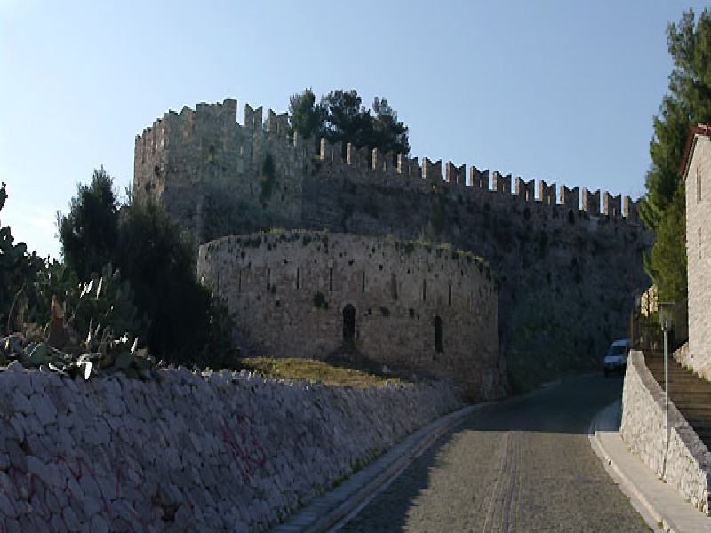
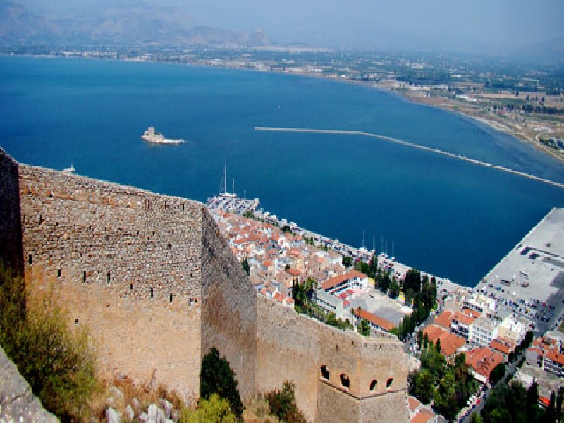
• Venetian castle in Nafplio (Palamidi) – 10 km of distance
The Venetian castle of Nafplio, a hallmark of the struggle of the Greeks for freedom, combines uniquely impressive views of Nafplio and the Argolic Gulf, endless romance and vivid images of the past, deservedly winning a place in the most attractive destinations of Greece. It is also the most representative monument of the city of Nafplio and symbolizes its physiognomy and history. Perhaps the most beautiful Venetian castle in Greece was built in the early 18th century in just three years, while its size testified to the importance of the city for the Venetians. In particular, it was completed in 1714 in a record time of just a few years, to serve the military and naval operations of the Venetians of that time. Later, in the years of the Ottoman Empire, one of its bastions was converted into a prison. Moreover, Palamidi became synonymous with the return of Nafplion to Greek hands and with the central position that the city was destined to occupy as the first capital of the Greek state.
The Hill of Palamidi owes its name to the Homeric hero Palamedes. For the record, Palamedes took part in the Trojan War, but did not return. He was accused by Odysseus of treason and murdered.
The castle is 216 m. high and what will be unforgettable in Palamidi, is the architecture and the size of the castle. Kolokotronis is associated with Palamidi even with the legend about the 999 steps of Palamidi, since according to oral folk tradition the thousandth step was broken by The Horse Of The Old Man of Morea.
Palamidi, however, apart from being an important fortress, was also a place of notorious prisons. In Palamidi, two bastions stand out: Miltiades, where later imprisoned the hero of the Greek Revolution, Theodoros Kolokotronis, accused of treason, and Saint Andrew, which was also used as a prison. Specifically, in 1834 Theodoros Kolokotronis was imprisoned in Palamidi for 11 months, along with Dimitrios Plapoutas, for high treason by the Regency regime. The area considered as the prison of Kolokotronis today has taken on legendary proportions and receives many visitors daily.
In 1962 Palamidi was designated as a visitable archaeological site. Until today Palamidi operates as an autonomous archaeological site, with great visitors all year round, keeping almost intact the image of a Venetian fortress complex.
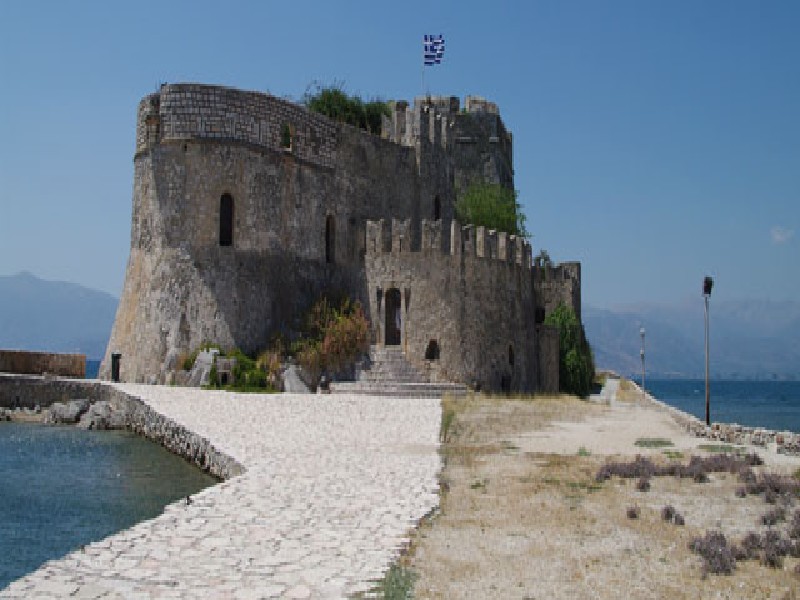
• Venetian castle in Nafplio (Bourtzi) – 10 km of distance
The small but enchanting Castle of Nafplio, Bourtzi, is one of the top landmarks of the city. The castle was built in 1471, during the 1st Venetian rule, by the Italian architect Antonio Gambello. This is why its name comes from the Italian and is “Castello dello Soglo” or “the Castle Of Dreams” and for the port “Porto di cadena” or “port of the chain”, because every night they stretched from the bastion five brothers in Acronafplia (also known as Its kale at that time) to Bourtzi a chain and closed the port for safety, while the Turks later surrounded it with “porpela”, an underwater barrier of stones so as not to be it is possible to approach large ships.
However, the name that has prevailed is “Bourtzi” and comes from the Turkish-Arabic language and means “island-fortress”, while it is the trademark along with the castle of Palamidi for Nafplio. The small island in which there is the castle or Kastelli, was called the island of Agioi Theodoroi and Thalassopyrgos later in the years of the Revolution.
Bourtzi, after several times changing hands between Venetians and Turks, finally in 1822, was occupied to be used against Acronafplia in its siege by the rebellious Greeks. After the liberation in 1826 in Bourtzi, the Greek government fled twice to escape the nation’s civil war, around 1865.
Bourtzi ceased to be used as a castle after the advent of King George A΄ and by his order in 1865 it was disarmed and became a place of residence for the executioners who handled the guillotine for the execution of prisoners of Palamidi and Akronafplia, which also became prisons of the Greek state.
After World War II, in the 1930s the German architect Schaeffer designed and converted the castle into a hotel, which was operated by private individual and hosted famous figures until 1970.
Today its outdoor space is used for cultural events while a part of it regularly functions as a conference space. To visit Bourtzi you should use the small boats that are located in the Port of Nafplio. The distance from the port with them is only 10 minutes and you give a tour time of 20 minutes.
POINTS OF INTEREST
• Acronauplia
Akronafplia is a rocky peninsula that was in ancient times the Acropolis of Nafplio. It is located opposite Bourtzi and right of Nafplio at the entrance to the Bay of Argolikos. It is accessible only from the north through an artificial historical ravine called Arvanitia.
Akronafplia is one of the three excellent castles of Nafplio and was the walled settlement of Nafplio from antiquity until the end of the 15th century. The current form of the castle of Akronafplia was crystallized mainly during the Frankish and first Venetian periods, from the 13th to the 16th century.
Acronafplia, however, has a long and ancient history, as evidenced by its walls, part of which is Cyclopean. In Akronafplia the existence of a prehistoric settlement was identified, while in the western part of the Acropolis parts of the ancient polygonal walls dating from around the end of the 4th century BC are preserved. Remains of walls however are preserved from the Hellenistic as well as the Byzantine period.
Consequently, the history of Acronafplia follows the historical fate of the region that fell to the Romans, Byzantines, Franks, Venetians and Turks of the Ottoman Empire, until the liberation of Greece.
It is noteworthy that in 1822 the flag of freedom was raised here by Theodoros Kolokotronis, who a decade later found himself imprisoned in the castle.
Also, since 1884, the military prisons were housed and during Metaxas, in the cells of Akronafplia, the political opponents of the regime, mainly communists, were found. This continued during the German occupation.
Today one can visit the castle of Akronafplia either by climbing the Catholic Church’s road staircase and the gate of the castle of Toron or by using the elevator of the Nafplia Palace Hotel, which is probably the easiest way.
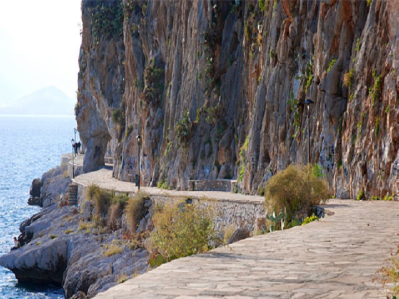
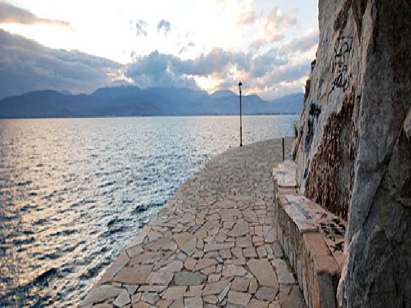
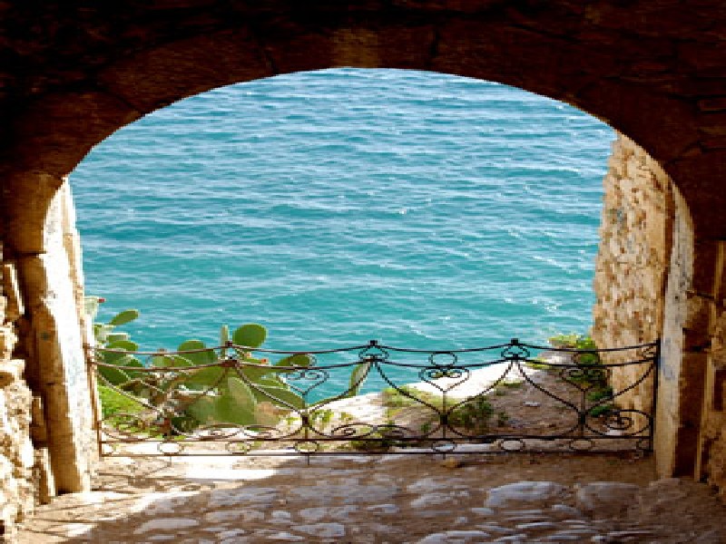
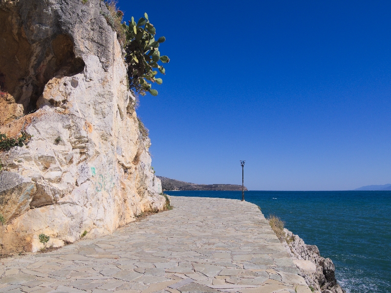
• Arvanitia Promenade
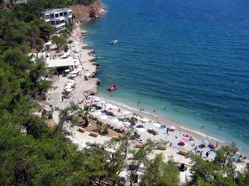
The Arvanitia Promenade, as it is characteristically known by local residents, is one of the most popular walks in Nauplion. It starts at the end of the shore and leads to Arvanitia Square, a total distance of about 1 kilometre. The whole of the route is dominated by the rock of the Acronauplia with its impressive walls. About half way through the walk one comes across a small church perched on the rocks, a favourite place to visit for residents and visitors alike. It is known locally as Panagitsa, Panaghia tis Spilias, or Santa Maria della Grotta to the Venetians. The view of the Gulf of Argolis from this spot is unique. The walk comes to an end in Arvanitia square. According to local tradition, this area was given the name of Arvanitia because it was from off these rocks that Kapetan – Pasha threw the Albanian mercenaries who had overrun the area in 1779. In reality, the name is due to the fact that Albanians had inhabited the area outside the walls and to the east of the Land Gate since before the time of the first Venetian occupation. Further down from the square there is an organized beach area, where one can go to relax, sunbathe and swim. Moving on from the square, one can continue walking to the east, along the foot of the Palamidi and reach the sands of Karathona, a total distance of about 2.7 kilometres. If one wants to return to the old town from the square, one should head downhill towards Staikopoulos Park and the Land Gate.
ESCAPES
During your stay, it is worth visiting the picturesque islands of Hydra, Spetses and Poros. For those who love the sea, there is a daily cruise to Hydra and Spetses. Its starting point is the port of Tolo, which is at 2 km from our hotel. Whoever wishes to drive there, will arrive following a wonderful itinerary through traditional small villages and reading the signs.