
We recommend some remarkable Trekking Greece routes for your Nafplio holidays.
- Saint Spyridon
- Kastraki
- Hill of Prophet Elias
- Holy Monastery of Saint Dimitrios Avgou
- Monastery of Polemarcha
- Artemisio Mountain
- Mountain Parnonas
- Mountain Taygetos
- Mountain Ziria
- Mountain Dourdouvana-Triantafilia
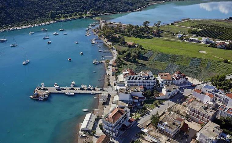
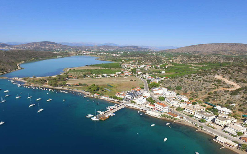
Saint Spyridon – 3.3 km
For lovers of hiking trails and sports, we recommend the 3.5 km scenic route, from our accommodation to the small church of Saint Spyridon, along the lagoon of Vivari and through Citrus Estates. Saint Spyridon in Vivari, is the chapel that romantics prefer to make their wedding. Experiencing absolute tranquility, either in the morning hours of sunrise or at sunset, we suggest you enjoy this beautiful route, with the enchanting colors and the aroma of citrus that nature offers.
Kastraki – 2.5 km
Between the Gulf of Tolo and the beach of Plaka of Drepano, at 3 km. from the accommodation, the peninsula Kastraki, which has been identified with the Homeric Assini, emerges. The ancient Acropolis of Asini rises to the top of the steep hill on the edge of the sea, where there are the walls and ruins of the Acropolis. Two perimeter routes to the lower City and the Acropolis are included through information signs for metal and wooden bridges and scales at precarious points of the route. Additional organization and safety on the paths, are provided by the installed sitting areas, garbage bins and canopies at the mouths of wells and reservoirs. Three newer, small buildings are used as an outpost-shop, a multimedia room and an exhibition space with the history and methodology of the excavation process, where digital tour applications are presented ( digital map, timeline, visualized history of the area, three-dimensional depiction of the bath and 3 short videos on the subject of the Italians in Asini and the destruction of the site, the Swedish excavations in 1972 in Asini and an application on the history of the archaeological site ) .
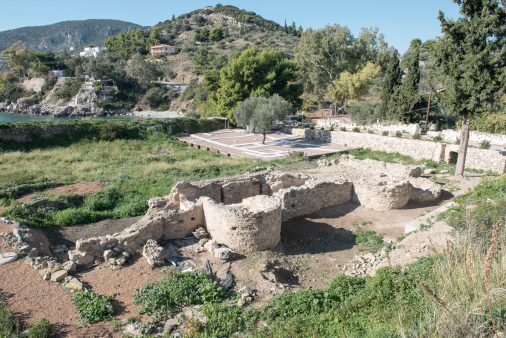
In the interior of an artificial cave in the southeast of the Lower Town is presented the modern history of the Italian occupation in Assini with the exhibition of supervisory material. The trails of the historical area have been visited by tourists from all over the world for many years and thus the monumental remains are highlighted and represented. It is worth noting that the archaeological site covers the needs of people with disabilities: entrance ramp, W.C disabled headers and guide for blind subtitles in digital applications for people with hearing problems. The chapel of Panagia that flaunts in the center of the Acropolis performs mysteries such as weddings, baptisms overlooking Kastraki Beach, Cosmopolitan Tolo and the islet Agioi Apostoloi. Around the Acropolis of ancient Asini there are organized traditional accommodation such as camping, rooms to let, studios, apartments, bungalows, as well as taverns and bars that travel you to that time wondering about yourself.
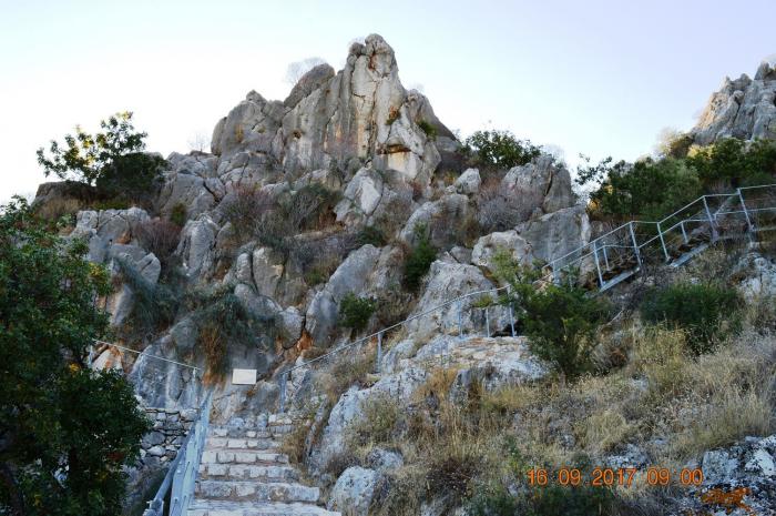
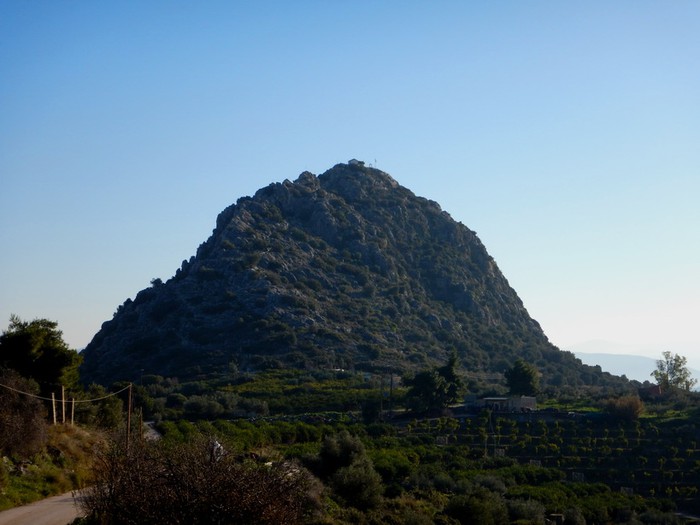
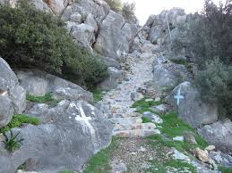
Hill of Prophet Elias – 3.3 km
The chapel of Prophet Elias is built at 119 meters on the top of a high mountain, which is shaped like an egg and at night illuminated exudes a unique feeling. It is located in the settlement of Saint Paraskevi – Tselou, imaginatively United with Asini, which is built in the foothills and is the next village just 5 km from the accommodation. In Prophet Elias of Asini for some years, with the care of volunteer residents, 449 steps have been built and the chapel is more accessible for pilgrims. On the eve of his feast day, July 19, they climb to the top of the mountain and spend the night there, preparing for the religious ceremony of the feast the next day. With a 25-minute climb, one reaches the chapel of Prophet Elias and from there one can see half of Argolis. If it has good weather conditions, it can even see Spetses. A route worth walking and in the end you will be compensated by the excellent view of citrus trees and the sea.
Holy Monastery of Saint Dimitrios Avgou – 8.9 km
The Holy Monastery of Agios Dimitrios Avgou is one of the most important Christian monuments and sights of Argolis and is 25 km from the property. Its origins date back to the 11th century and it is located near the village of Didyma Argolida, on a steep side of Didyma mountains, almost an hour away from the accommodation. Specifically, it is built above the Valley of Iria and in the northern part of Mount Avgo, while it has an altitude of 320 meters. Its location is directly intertwined with the river Rados, which you cross if you want to reach the monastery, starting from Iria, a rough dirt road. Access is from the village of Karnezaiika Irion to the West, a pleasant route to mount egg.
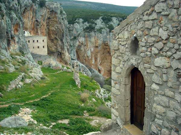
Specifically, at a distance of 2 km. from the village of Karnezaika, begins a road near the river Rados, which leads to the monastery, about 8 km away, between olive trees and orchards, always next to the river, while to the south of the route rises the large mountain range formed by Iria: the natural boundary of Nafplia with Ermionida. Slowly the soft landscape in the plain of Iria, becomes coarse and imposing with its mountainous ravine composition. The monastery stands out from afar in the shade of its northern orientation and 1 hour walk brings us close to it. In the nature-loving hiker, if he helps along a fine spring day, a unique panorama will be revealed. A nature that changes little by little form, and from tame and lowland, is changed into wild, proud, mountain-rising, over the lips of the ravine’s cliffs, as down deep with it the foaming waters rush. Transparent light, light and fragrant air, pasicharo color, the bloom of wild mountain vegetation and among it the form of rocks in alternating, anthropomorphic shapes, vary impressions and help climbing on Romanian paths, difficult for the foreigner and the ignorant.
Μονή της Πολεμάρχας – 6.2 km
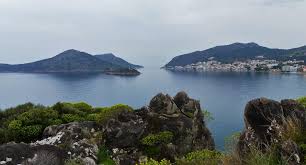
Near the settlement of Nea Epidaurus, on a deserted beach with pine and olive trees, is the dissolved Monastery of Polemarcha. Polemarcha is located in Ancient Epidaurus and consists of two beautiful beaches with clear blue waters and a pine forest that shades the whole place. Between the road of New and Ancient Epidaurus, there is this beautiful medieval monastery, built in the 15th century, which was abandoned after repeated pirate attacks and for this reason, in the building there are several battlements, probably for flintlock, as a defense against invaders.
Specifically, from the paved road of the port of Ancient Epidaurus to the Monastery of Polemarcha, there is a picturesque seaside path, with very good signage, which can combine both hiking and recreation. So it gradually climbs the mountain, where the view is amazing, then descends and returns to Ancient Epidaurus. The route is easy and the path is discernible, while towards the end, we find the foundations of a temple of the Goddess Artemis and in the outskirts of the city tombs of the Mycenaean era. Especially in the summer months it is an excellent destination for nature lovers, but also for those who prefer alternative escapes. The path of Panagia Polemarcha is of medium difficulty and its duration does not exceed 3.30 hours. Remarkably, we note that the route is parallel to the sea and in several places approaches it so that one can easily stop there.
The walker walks having on his right the coastal arch and gazing at the sea and on his left the village of Ancient Epidaurus throughout with a dominant image that of the Church of Saint Nikolaos, patron saint of the village which is built on the ruins of the Temple of the Goddess Hera.
Artemisio Mountain – 9 km
Artemisio is a mountain of the Peloponnese, located on the border of the prefectures of Argolis and Arcadia. It is part of the wider mountain range that connects the Corinthian Gulf with the Argolic Gulf. Its highest peak is located east of Nestani and the most common routes to conquer its peak (at 1,771 m.), start from the village of Karya, thus making it the 13th highest mountain in the Peloponnese. The view from the top to the surrounding Peloponnesian mountains and the Argolic Gulf is unique and rewarding. Pausanias and Aeschylus mention that at the top of Artemisio there was a sanctuary and statues of Artemis, with whose worship it was, in antiquity, inextricably linked . He also mentions Mount Artemisio as a pass, on the road leading from Argolis to Arcadia, from Argos to Mantineia. Artemisio is among the 196 Important Bird Areas in Greece. As mentioned above, from Karya, in the eastern foothills, start the two main routes to conquer the peak of Artemisio. The southern (difficult) route includes the crossing of a well-marked path, where from scallops will lead us to the top. Where there are exposed passages a rudimentary care is needed, and if the ascent takes place in the winter months, it is possible to use rope in some places. The northern (easy) route is also the most common. Leaving from Karya, we follow the uphill asphalt road (leading to Nestani).
Go-Come on, the whole journey should take 3-5 hours at a moderate pace.
Through Artemisio pass the tunnels of the National Road Corinth-Tripoli and thus the village is accessible from it. Specifically, we exit the highway at the height of Sterna coming from the North and at the height of Neochori coming from the South. From the Provincial Road Sterna-Neochori, we take the road towards Karya near the Western exit of Lyrkia.
Mountain Parnonas
Parnonas is the most extensive mountain complex of the Peloponnese and creates a huge mountainous area, overgrown with fir and black pine trees, full of meadows and waters. The highest peak of the complex, the conical Grand Tourla (1935 m.), is located at the northern end of the complex, over a large, beautiful plateau. Being an important link in the oreographic system of the Peloponnese, Parnonas is crossed by two major mountaineering routes, the European path E4 and its offshoot, The National path O33. Both, however, are based on the road network and have no particular hiking value.
Fortunately, however, a large part of the network of paths that connected the villages with the mountainous resources or other destinations is preserved. Based on these paths, some interesting hiking units have been formed, the most remarkable of which are the 16 routes around Tsitsina, marked in 2000 by the Greek Mountaineering Club of Sparta and the Outdoor Life and the group of 4 routes around the villages Kastanitsa, Prastos, Sitena and Platanos.
More generally, the main interest in Parnonas is limited around two major poles of the mountain: the refuge of the mountain of EOS Sparta and the peak Megali Tourla, which with its steep slopes and conical shape, is indeed quite impressive. The routes leading to the base of Megali Tourla reach from Sitaina, the Malevi Monastery and the refuge of EOS Sparta, but only the part from the Monastery to the refuge follows a path.
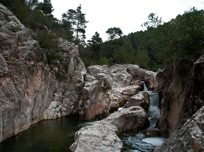
Finally, it is worth visiting the waterfalls of Lepida, one of the most beautiful and yet unknown natural wonders of Parnonas. The rocks around the waterfalls are ashy in colour and the water falls with special force on them. The area smells of oregano, sage while the small plane trees on the stones compose a unique picturesque landscape. The gorge of Lepida is one of the most interesting natural and wild landscapes of the Peloponnese, while despite its small size, it has to show a rare wealth of natural beauties. Apart from the rich flora that changes giving each time a different colour representation depending on the seasons of the year, it also has an amazing aquatic world that for our good luck is easily accessible.
In particular, the wonderful waterfalls of Lepida are located in the omonynos gorge at a distance of 4 km from the village of Saint Giannis of Parnonas. The large waterfall has a height of 70 meters and the small one 45 meters. Mountaineering clubs organize canyoning in the gorge and rappelling with rope at the waterfalls, while in summer there is the famous swimming pond.
The great waterfall of Lepida in Arcadia, in fact refers to a set of smaller waterfalls divided into three levels. In total we measure 70 meters of waterfalls that when they have water they create the most melodic song you have ever heard.
Mountain Taygetos
Taygetos is called the highest mountain range of the Peloponnese and took its name, according to Greek mythology, from Taygeti, one of the Atlanteans, who in order to escape her shame after her involuntary mating with Zeus, put an end to her worldly life . Its highest peak reaches a height of 2,405 meters and is called Profitis Ilias or Agiolia, from the homonymous chapel built near its top. A characteristic feature of the mountain range is its five peaks (because of them it was called Pentadaktylos in Byzantine times). Like all mountain peaks, it was considered a sacred site because it was the closest point to the sun, and people believed it was the most appropriate place for their prayers to be heard better.
Taygetos, with its excellent cobbled streets that start from the plain and continue with demanding paths to the high peaks, offers the climber a complete field of adventure and uplift. In its paths, there are myths and legends that wrap its slopes with a mysterious aura. Many myths exist around the mountain, but the most characteristic is the pyramid that forms its top. It is so faultless, a perfect isosceles triangle, that it is said not to be natural, but was carved by human hands for possibly devotional purposes. Mysterious lines that connect it with various symbolic points, three different pyramids in specific coordinates and other beautiful ones give birth to the mystery. Walking along the trails of Taygetos, a hiker can see the geological history of 200 million years. Hiking to the highest peak was a major achievement for the ancient Spartans which it still is today.
Beautiful villages perched on its slopes, rough paths, fertile valleys, successive ravines leading to the sea, steep peaks and large plateaus are the main features of Taygetos. On the West Side is the area of Kalamata and on the East Mystras and Sparta. Most of it is covered with fir and black pine trees, and has a large number of streams and small rivers. With coniferous forests, ravines, plane trees, crystal springs and a dense network of paths, the proud giant invites you to cross it to reveal its symbolism. The flora of Taygetos is extremely rich and includes more than 1,000 species of plants. Of these, 33 are endemic to the region and 100 are endemic to Greece. But there are also species that, without being endemic, are very rare for Greece and Europe and have Asian origin.
In Taygetos there are many routes that lead to its peaks, but also old paths, ideal for climbers and hikers, that start from the villages in the lowlands and reach the most remote mountain settlements. Two or three days are required for the runs up to the top. The trails are very well marked, ideal for ascents in the summer, while the large gorges attract every summer many hikers and climbers, as their crossing offers many thrills in sports activities in the wild mountain nature. The best thing to do is to go up in the afternoon, to see the sunset, to stay overnight there and after sunrise to return. So do the faithful of the region every summer, at the feast of Prophet Elias, an impressive ritual that gathers hundreds of people. If you wait until dawn, just before sunrise you will experience a miracle, while the view from the top is amazing, as you can see the three legs of the Peloponnese, Kythira and even Crete. The most important sight, however, is the perfect shadow of the pyramid, as the researchers call it, is a natural phenomenon that you can only see from the top of the mountain. The shadow of the mountain creates when the weather allows, in the morning, an equilateral triangle in the Messinian Gulf. It is caused by the refraction of the light of the sun that is about to dawn on this place.
Mountain Ziria
Megali Ziria is one of the most famous mountains in the northern Peloponnese and is the second highest mountain of the Peloponnese. Its name comes from a Slavic root meaning “Acorn”. Its height exceeds 2,300 meters and is suitable for gentle hiking trails, cycling, as well as mountaineering skiing. It has an extensive Alpine field and is divided into two main peaks, Profitis Ilias and the slightly higher one called Point. A panoramic landscape, full of paths, enchanting routes and small natural treasures, waiting to be discovered. Above the villages of Trikala Corinthia, there is a small ski resort which operates at an altitude of 1,550 meters.
You can enjoy the whole landscape either by hiking on the organized and marked trails or by unique routes, through the forest, by conventional car, jeep or motorcycle. At the same time, the morphology and the mountain road network are offered for mountain bike rides, while the important mountain running race Ziria Skyrace, gathers hundreds of participants every year. Each path has a different color and shape symbol to avoid misunderstandings. On the mountain there are many forest roads, which give you the opportunity to get to know the most hidden corner, with the most prominent route that crosses the plateau and ends in Goura, through a rich fir forest, where we often meet semi-wild horses.
You can easily make it on your own on the marked or not trails or apply to alternative tourism companies (Adventure) and the sports ski center of Zireia.
The most popular routes start from Trikala Korinthias, climb to nudibranch and head either to Flabouritsa or to the highest peak of Ziria, passing by katafygion B. The Flabouritsa Valley, part of the Natura 2000 network, divides the mountain into two distinct volumes, the so-called Megali Ziria (where the highest peak is 2,374 m.) and Little Ziria (2,117 m). It is crossed by the Sytha River which flows into the Sea of Xylokastro, and displays intense biodiversity. But also from the end of the path, at the peaks of Zireia, the view spreads even further, up to the peaks of Parnonas to the south and the Argolic Gulf, even further east. A path where walking will accompany you the sound of running waters, this is the ideal path.
Also of great interest is the ascent from the village of Manna to the steep peaks of Mikri Ziria, where it hosts several routes, starting from the villages Kefalari and Kyllini.
Mountain Dourdouvana-Triantafilia
Dourdouvana is the second highest peak of Mount Pentelia and has an elevation of 2,083 m. Due to the amazing view it offers towards Lake Doxa, it “steals” the interest from the highest peak of the mountain called Triantafylia and has an altitude of 2.109 m. The name Dourdouvana (or else Pentelia) has a slavic root and means rose. It is a relatively small mountain, which is the southernmost end of Helmos (or Aroanian mountains), with two peaks of more than 2,000 meters, Dourdouvana ( 2,078 m. ) and the Triantafilia (2,109 m. ), on the borders of the prefectures of Achaia and Korinthia. Around the perimeter of the mountain, a forest of fir trees dominates, while at its foot grow mainly deciduous, such as plane trees, willows and poplars. In several places the black pine is found, both low and higher just before the alpine region.
The reference point of the area is the artificial lake Doxa and the surrounding mountain peaks. The idyllic Lake Doxa, is a small artificial lake with turquoise crystal clear waters, created 30 years ago with the construction of a dam on the plateau of Feneos Korinthia at 900m. high altitude. It is a unique wetland, surrounded by forest with plane trees, pines, firs, cedars and chestnut trees and gives the visitor many alternative options.
One of these mountain peaks is Dourdouvana or Mount Pentelia. Just from the lake, however, one of the most beautiful and classic ascents in the mountains of Moria takes place and is none other than the ascent to Dourdouvana, the mountain that dominates the landscape. Essentially, Dourdouvana is the continuation of the southern ridge of Helmos, separated from it by the well-known ” Hunter’s gap “. Just off the perimeter road of the lake (at its most westerly point) there is a junction leaving West over towards the forest. There is also a yellow large sign “to Dourdouvana”. The ascent is marked with a red-and-white square, and indeed quite thickly, where we shall meet with no trouble even in bad weather.
More specifically, the path to the peaks of Dοurdοuvana starts from the western side of Lake Doxa and has an altitude difference of more than 1,000 meters. At first we follow a dirt road and then we move on a fir-covered slope, heading mainly west, having quite good signage and an impressive view of the lake below us. At 1,550 meters distance of 2 hours we are now at the famous Hunter’s gap, which separates Dourdouvana from the Helmos mountain range. From the Hunter’s Gap the path takes direction south, the vegetation begins to thin, while the slope gradually increases. It is the most arduous part of the route, but the view from the ridge is magnificent and impressive to all the peaks of the northern and central Peloponnese. As we continue the slope increases until we reach the gap (close to 2,000 m.) between the two peaks of Dourdouvana, Dourdouvana on our left and Triantafilia on our right. The distance for the two peaks is about the same, about half an hour. From the peaks of Dourdouvana you have an endless view to all the peaks of the northern and central Peloponnese, while from the lower peak Dourdouvana you are also lucky to enjoy from above all the splendor of the emerald Lake Doxa. The total duration of the ascent is about 3 half hours and another 3 hours for the descent.